Ansty
Walk 2 - Ansty to Handcross
Distance: (7 miles / 11km)
Grading: Moderate
OS Explorer map: 134 (Crawley & North Horsham)
Start point:
Ansty Recreation Ground (car park), Deaks Lane RH17 5AS
End point:
Handcross Recreation Road (car park), High Street RH17 6DU
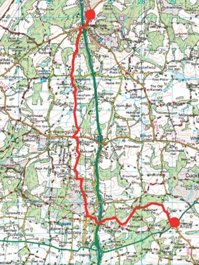
1.Start at Ansty Sports & Social Club (WAYMARKER 2), come out of the car park and turn right down Deaks Lane, walk past the vineyard and then turn left through a gate and up a couple of steps onto a signposted footpath with the woods to your right.
2.Walk on with the vineyard to your left, then through a gate onto a wide muddy path and keep to the main path through the woods until you reach Pickwell Lane.Cross over the road and go through the 5-bar gate marked Raggets, past the white house on your right and continue straight on a wide grass path with fences either side.
3.Cross stile ahead and follow the path until it turns to the right, go down the hill through trees to Buncton Lane, turn right and walk a short way uphill past Woodland Farm to a large house on the right, then turn left onto a footpath that is signposed Diamond Jubilee Walk.
4.Follow a windy path through the woods over a couple of little streams until you can see traffic on A23 ahead. Go over a stile and turn left alongside the A23, go down some steps and turn right to go under the pedestrian.
5.At the junction, turn right and head north on the pavement toward the Equestrian & Country Store, then cross the road to turn left into Top Street.
(Resting Place (3 miles / 5km): Do not turn left, continue straight up London Road for about 10 minutes until you reach the Bolney Stage (RH17 5RL) on the right - a dog friendly traditional pub and restaurant. Other refreshment options in Bolney include the community café at Rawson Hall, Batchelor’s Field, the Eighteen Acre Café at Bolney Wine Estate, Foxhole Lane or the Cycle Café in Top Street –opening times vary).
6. There is no path so be mindful of cars and walk on until you reach a bend in the road and a public footpath sign directing you to turn right and follow The Street out of the village past The Thatched House which is to the left.
7. Walk on to a five-bar metal gate and follow the path past the farm buildings and a horse field on your left. Go under a brick bridge and continue uphill to a footpath crossroads where you keep going straight on and downhill intoa little wood. Keep the metal pylon on your right.
8. The path can be quite boggy and there are bluebells here in the Spring. Go over a wooden plank bridge and carry on the windy path through the woods, over another bridge and follow the public footpath sign into a field where some saplings have been planted.
9. Cross over a track, then over a stile and head across the field, for the path becomes quite steep for a short way until you reach a stile at the top.
10. At Jeremy’s Lane, turn left past Firdene and follow the road as it snakes round past some houses, then turn right onto a drive marked North Cottage and then follow the narrow footpath to the left. It is quite shady with overhanging branches and you may need to duck down in places.
11. Go through a gate and head to the left across a field, toward the water tower in the distance, then cross the next field, over a stile toward a gap in the hedge opposite and over another stile, keep the fence to your right and head for the gate.
12. Cross over a little track that runs down to the farm on your right-hand side, through the gap in the hedge and follow the public footpath sign, look out for the electric fence on your right!
13. Go through a metal kissing gate, continue on through two gates and over a wooden plank bridge into a field, walk straight on, on a path with woods to either side with cables overhead.
14. The path turns to the left, alongside and then through the woods and across some horse fields, over a stile and straight on at a footpath crossroads, past the paddock and stables on your left.
15. Go over a stile and turn left over a cattle grid and down the drive to reach Cuckfield Road where you need to turn left, there is a grass verge but no pavement so beware of traffic, cross the road and follow the footpath on the right.
16. Bear diagonally right towards a pylon at the edge of a wood ahead, the path continues on and then turns to the left downhill through the woods and out into a field. Head down toward the right of the house ahead and follow the path between two ponds.
17. The path turns slightly right and continues on until it joins a track leading to a large mill pond. Keep the pond to your left, cross the tarmac drive and follow a footpath that turns off to the left along a fence by the mill pond edge. The path bears right after the footbridge.
18. Follow the bridleway north until you reach the churchyard at St Mary’s Church, Slaugham. Pass to the left of the church and Go out through the lychgate and cross Staplefield Road to walk into the village ahead. Walk past the houses and a white telephone box on your left, continuing until you reach a white gate ahead marked ‘Slaugham Park, Private Property’, go through the pedestrian gate on the left and continue along the road.
19. Keep following the wide path passing between a pair of metal gates, until you reach the main road where you need to turn left. Cross over at the islands to turn right along the pavement, the road bridge crosses the A23, and turn left at the road junction. Walk 3 continues into Nyman Woods opposite but turn left at the Red Lion pub for Handcross Recreation Ground and car park (WAYMARKER 3).
If you prefer you can download the walk guide to your phone.
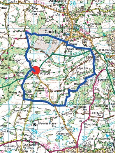
Walk 9 - Ansty Circular
Distance: 7 miles / 11.3km
Grading: Moderate
Location: Explorer maps OL34 (Crawley & Horsham) & 135 (Ashdown Forest)
Start/End point:
Ansty Recreation Ground,
Deaks Lane RH17 5AS
- Leave the car park recreation ground (WAYMARKER 2) and turn right down Deaks Lane. Walk for a minute then opposite 4 Lavender Cottages turn left down a driveway signposted public bridleway.
- Walk through a wood yard and then the public bridleway turns off to the right through some trees and between deer fencing on either side.
- Go past a bungalow called Silverdale and continue on the public bridleway. The path goes around the back of the houses and leads out onto the A272 where you will need to turn right and cross over almost immediately to keep following the public bridleway. It is quite a dangerous crossing on a bend so be careful.
- Follow the bridleway opposite until you reach Bishopstone Lane where you need to turn left and walk slightly uphill. Go past the public footpath on your left, past the cottages on your right and then turn left along a public bridleway, through a gate.
- The bridleway leads to Cuckfield Road where you need to go directly across to the path on the other side. Follow the bridleway until you come to a field, walk along the left-hand edge with trees to the
- Continue on between a hedgerow on the right and the tree line on the left until you reach Harvest Hill. Cross straight over onto the driveway leading up to Moonhill Farm and turn directly right onto a public bridleway through the trees.
- Turn off the bridleway through a kissing gate on the left signposted public footpath. Walk along the left-hand side of the agricultural field, and turn right when you reach the copse, follow the edge of the woodland to keep heading north until you reach Upper Ridges Cottage on your right (just before the cottage the waymarked path follows a track to the left of the hedge).
- Follow the footpath in front of the house and continue towards the bottom right hand corner of the field until you reach a little brook where the path goes left and immediately right. Go over a stream, left uphill through a wooded area and then through a gate into a field, keep to the right-hand side of the field.
- Go through a metal kissing gate, diagonally left across the field and round the back of the house and then toward a gate in the left-hand corner of the field. Keep to the left-hand edge of the field, go through a kissing gate and diagonally left to gate in corner of field beside a bungalow. Follow the path along the left hand side of the field, beside a fenced off area of woodland.
- Go past a tumbledown shed on your left and then turn left across the field toward the trees, walk past two large trees to your right and you will see a footpath ahead that leads into the woods.
- There is a steep gulley to your left, walk downhill over a stream and up the other side. Over a stile, keep walking straight ahead, there is a fence on your left.
- Go over the stile, past the farmhouse and over another stile. Over one more stile and then cross over a lane to carry straight ahead, through a kissing gate and across Copyhold Lane. Follow the public footpath straight ahead between two fences until you reach the A272.
- Go straight across the main road to pick up the footpath directly opposite and then turn left along the fence behind Warden Park School on the right. Keep walking straight ahead until you reach a track which runs along the south hedge of the cemetery at the Holy Trinity Church, Cuckfield.
- Just before the footpath turns sharp left (and the track continues straight ahead) you need to turn right through a metal gateway and walk directly through the cemetery toward the church spire.
Resting Place (5 miles / 8km): Turn right in the cemetery toward the war memorial and under the tree you will see the ‘Feather Bench’ made by artist Christian Funnell. The work was commissioned by Cuckfield Parish Council in 2019 to ‘remember the many babies who rest near this place’. Cuckfield is a good place to stop for a coffee or a pint as there are several good pubs and cafes.
- Walk past the church and turn left though the lychgate and walk straight on down Church Platt, round the back of the White Hart Pub. Cross over South Street and turn left through a gate to follow the High Weald Landscape Trail.
- Go through a kissing gate, down a steep path to a stile at the bottom. At the bottom of the hill there is a little stream and a wooden bridge, on the other side there are some steps going uphill.
- The path continues on, through a kissing gate, then the path turns downhill until you reach a little stream, go over the wooden bridge with a handrail and then uphill toward Deaks Lane.
- When you reach the road turn left, there is no footpath but it is a relatively quiet road with little traffic. Follow Deaks Lane all the way back to the Ansty Recreation Ground car park (WAYMARKER 2).
If you prefer you can download the walk directions to your phone