Crawley Down
Walk 5 - Crawley Down to East Grinstead
Distance: 3 miles / 5 km
Grading: Easy
Location: OS Explorer map 135 Ashdown Forest
Start point:
Burleigh Way Car Park, Crawley Down RH10 4HJ
End point:
East Grinstead Railway Station Car Park,
Grosvenor Road RH19 1HS
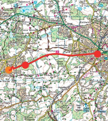
1. Set off from the car park, heading away from the shops, down Burleigh Way following the Worth Way signs. This is a relatively short, flat walk following the old railway line, which is well signposted all the way.
2. Continue on through the residential housing, right down Woodland Drive and then left into Hazel Way. When the road turns to the left, bear half right into Cob Close and pick up the Worth Way by Crawley Down Pond (WAYMARKER 6).
3. After about ¾ mile (1.2km) you will reach a crossroads with a bridleway to the North and footpath to the South, keep to the Worth Way and go straight on.
4. You will go under a bridge at Imberhorne Lane, another at Garden Wood Road and you will reach your destination at the East Grinstead Station car park Go across the road and continue straight on over the pedestrian bridge and down the steps (WAYMARKER 7) to reach the National Rail ticket office.
Walk 12 - Worth Circular
Distance: 6 miles / 10 km
Grading = Easy
Location: OS Explorer map 135 (Ashdown Forest)
Start/End point:
Burleigh Way Car Park, Crawley Down
RH10 4HJ
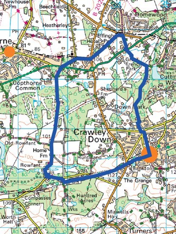
- From the car park, go west on the Worth Way toward Crawley on Old Station Close. Stay on the Worth Way, which is a wide flat bridleway, for just over a mile, past a sawmill on your left until you reach a junction at the entrance to the Rowfant Business Centre.
- Turn right toward the road, following the footpath to the right of the gate, over a bridge and past a pond on your left. Turn left and walk along the road for about 5 minutes, beware of traffic going in and out of the business centre, and then turn right at the driveway to Rowfant Lodge, bear right past the garage to join the driveway to Rowfant House.
- Turn left and follow the drive up to the house, go under the arch and turn to the right past the housing to follow the West Sussex Border Path left into the woods. The path veers to the right, a bit uphill and comes out on a track by Hill House on your left.
- Walk straight on past the row of houses on your left and continue onto a tree lined path ahead. Go over a stile and keep following the border path north until you reach a five- bar metal gate. Keep to the wide path and go straight on at the footpath junction to reach the busy Copthorne Common
- Cross the road (using the island to your left) to a track and bench opposite and follow the footpath which heads diagonally right through the woods. There are lots of windy paths in the woods but keep to main footpath heading left until you can see Copthorne Preparatory School through the trees on the left-hand side.
- The footpath comes out at a road junction by the entrance to the school and you should turn right down Mill Lane. At the end of the lane, cross over the road to join a bridleway opposite which is signposted Chapel Lane, leading to Copthorne Chapel on your right.
- Go past the chapel and carry straight on until you reach a road, cross over and turn right down the pavement for a short way until you see a public footpath on the right. Cross back over and follow the footpath down a wide drive that leads down to a house called Prevetts.
- The footpath runs to the right of the Rossley House metal gates. Go through a kissing gate, past a house, through another kissing gate and follow the path between two fences, under lots of trees.
- Go straight over the road and follow the footpath opposite down a private drive toward a house called Bruce Cottage. The footpath goes to the left of a red brick house, go through a gate and keep following the path between two hedgerows and over some wooden plank walkways. Continue to follow the path as it bears left.
- Go over a stream into an open field, head uphill across the field under the electricity cables to a gate at the top of the hill. Go through a kissing gate, turn right at the footpath junction and walk past a small- holding and the monastery on your left.
- The path narrows between two fences and comes out onto a tarmacked road, turn right here and keep following the lane until you reach some houses.
- Turn right at the public footpath sign and follow Cuttlinglye Lane around to the left, alongside the rear garden fences of a row of houses, until you reach the junction with Sandy Lane. Turn left toward the war memorial.
- Cross over Vicarage Road, turn right and then immediately left into Hophurst Drive where you will see a red post box on the right-hand side, follow the pedestrian path across a green with the health centre to your left.
- Walk straight ahead to Bowers Place, follow the road down past the green and children’s play area on your right. Turn left and Burleigh Way Car Park is on the left-hand side, opposite a row of shops
There are two hand drawn village maps in Worth produced by illustrator Helen Cann as part of the About the Place project. One is on the corner of Burleigh Way and Station Road in Crawley Down, near the car park at the start of this route and the other is on Borers Arms Road in Copthorne near the by the Parish Hub, which is a short walk from Copthorne Common Road.
If you prefer you can download the walk guide to your phone.