Handcross
Walk 3 - Handcross to Balcombe
Distance: 4 miles / 6.5km
Grading: Moderate
Location: OS Explorer maps 134 (Crawley & North Horsham) & 135 (Ashdown Forest)
Start point:
Handcross Recreation Ground (car park), High Street RH17 6DU
End point:
Balcombe Railway Station (car park), London Road, Balcombe RH17 6JQ
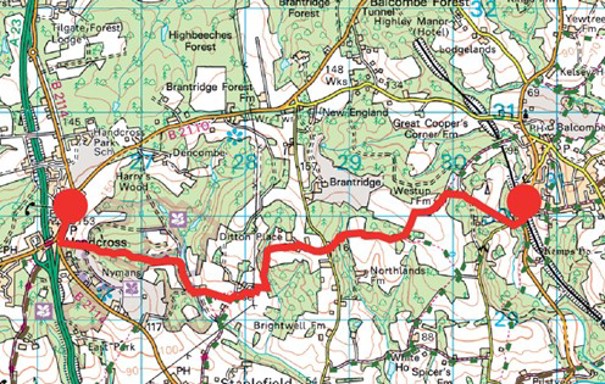
Walk 3 Directions
- Exit the car park (WAYMARKER 3) and turn right through the centre of Handcross toward the Red Lion pub. Cross the road to a small area of grass and a seat and turn left along the public footpath which leads through Nyman’s Woods (National Trust) between two of Nyman’s car parks, followed by a steep descent to a path.
- The path narrows and continues to descend through trees with some steps and can be very muddy after wet weather. At the bottom it joins another path coming in from the left. Bear right over a little stream (dry in the summer) then keep round to the left (do not ascend the path straight on).
- The path continues along the right bank of a small stream and widens to a track as it enters an avenue of redwoods. A pond and a lake can be seen below on the left. At the far end of the lake keep straight on do not cross the bridge onto the dam). There is now a large garden to your left.
- Following the footpath sign, bear to the left at a redwood with a slight descent and a sharp left down to a bridge over a stream with a dam to your left. Ahead a boardwalk leads over wet ground to a steep flight of muddy steps up to a gate into a field.
- Continue straight ahead along the side of the field with a hedge to your left, over a drive, past a post box labelled Old House Private Mail Only. The hedge turns left but keep straight ahead heading just left of a pylon on the skyline to pick up the hedge again on your left by the vineyard.
- Go through the gate at the far end of the field, bear left to cross a stream (dry in summer) by a wooden plank bridge, then up a slope keeping the fence on your left and grass to your right to emerge onto a drive. Turn right and immediately left up a drive which curves to the left leading to Allen’s Farm.
- A short way up the drive stone steps on the right-hand side lead up the bank to gate into a field. Straight ahead is a gate beyond which are power lines. Go under these and then immediately turn left through a gate into another field.
- Go diagonally to the right across this field heading towards a large gate in the right hand corner. Cross the stile beside a five bar gate. On the other side of this gate a path leads through the wood with a field to the left and a deep wooded valley on the right. The path turns right and descends steeply to the stream. Ignore the paths marked private on the right and descend to water level, and a bridge will be seen
- Cross this and follow the path up with the stream to your left. The slope is gentle at first, but the path curves to the right and steepens leading to a rocky sandstone path with a stream that flows down it in wet Take great care as the stones are very slippery when wet!
- Go through kissing gate into a field with an impressive house (Ditton Place, 1905, once a school, now apartments) ahead. Ascend the right-hand edge of the field past a house and through a gate at the top corner onto their drive. Leaving Ditton Place to your left go along the drive bearing right to eventually emerge onto Brantbridge Lane.
Halfway Point (2 miles / 3 km): Brantbridge Lane
- Cross Brantbridge Lane to a footpath through the hedge a few yards to your left, cross a track and walk on into the woods, the path bears left and right and then descends steeply down some rough steps into a gulley. The plank bridge at the bottom is narrow and there is wooden railing on only one side so go cautiously across the small stream and back up the steep steps on the other side. Continue to follow the waymarked path uphill.
- At the top, go over a stile into a cattle field, keep to left and walk on to a gate and stile into another field with a small pond to your left. Keep straight on along the edge of the field where there are views of the South Downs on a clear day.
- Go left over a stile at the footpath sign and follow the path to the right of the boundary hedge for a short way until you reach a wider track which turns right toward Westup Farm. Walk through the farmyard to the tarmac driveway, past the house on your right and go down the hill with a large pond to your left.
- The footpath goes left through a gate and about 30 degrees diagonally across the field toward some tall pine trees, then over a stile into a copse.
- Come out of the woods onto a road and turn left, go over the railway bridge then take the footpath off to the left. Walk up a short steep section to a stile and onto the London Road B2036. There is a layby for parking on the opposite side of the road, just to the north of the church.
- Cross the road using the island and turn right, then turn left along the pavement signposted toward Borde Hill Gardens until you reach the Half Moon Inn.
- At the pub, use the island to cross over and walk along Balcombe Hill a short way until your reach a red phone box and post box on your Turn left down Stockcroft Road, past the Victory Hall, then go right at the bowls club down a tarmac path between two hedges which leads to the recreation ground.
- Go straight on through the recreation ground, follow the narrow footpath round the back of some flats, then when the path opens out follow the footpath sign and keep walking on the pavement on the right. Turn right down Newlands and just before the postbox cross over the road, turn right and go down the footpath that leads to Balcombe Station.
- Cross the main road by the red telephone box (WAYMARKER 4), go over the station bridge and walk along the platform to the car park.
If you prefer you can download the walk guide to your phone.
Download the directions for Walk 3Walk 10 - Handcross Circular
Distance: 5 miles / 8km
Grading = Moderate
Location: Explorer OL34 Crawley & Horsham
Start point/End point:
Handcross Recreation Ground (car park),
High Street RH17 6DU
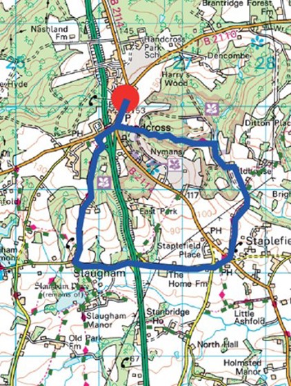
Walk 10 Directions
- Exit the car park (WAYMARKER 3) and turn right along Handcross High Street. At the Red Lion pub turn right along the pavement on the B2110 (signposted Cowfold and Horsham) which takes you over the At the mini roundabout, turn left and cross over the road using the island.
- Keep to the pavement on the right hand side until you see a public bridleway sign directing you right through a gate onto a road that looks like a private
- Ignore the paths to your left and right and continue straight on down, go past some grand metal gates and keep walking until you reach a big white gate just before you come to Slaugham village.
- Walk on toward the church and then turn left to follow Staplefield Road for just over one mile. It is a quiet country road but there is no pavement so take care and keep to the right-hand side to face the oncoming traffic.
- Walk past the Church Covert Woodland Trust nature reserve (14 acres of public meadows and woodland habitant) and the Slaugham Place housing development on the right-hand side, then walk on under the A23 road
- Continue on the road until you reach Staplefield Lane and the cricket clubhouse on Staplefield Common. Cross the common toward the war memorial, cross over the road, turn left and then right by the red phone and post box to follow the public footpath sign. There are two pubs in Staplefield if you are in need of refreshments
- Follow the path uphill, then downhill and over a stream, then when the path divides take the left-hand turn through a gate by a cattle grid. When you reach a house ahead with a little red post box, turn left and follow the public footpath sign through a gate, down some steep wooden steps
- Go over a wooden bridge over a stream with a dam on the right and then go up the hill into Nymans Woodland National Trust land with a big lake to your right. Follow the wide public footpath and keep left and uphill through the woods, getting increasingly steep as you reach the top (follow the public footpath signs and orange route arrows).
- At the Nymans car park go straight across and continue on the path which comes out opposite the Red Lion where you need to turn right to go up the High Street, back toward the recreation ground (WAYMARKER 3).
Refreshments available at the Red Lion or Jo.Co Coffee shop in the High Street
If you prefer you can download the walk guide to your phone.
Download the directions for Walk 10