Lindfield
Walk 1 - Lindfield to Ansty
Distance: 6 miles / 9.5 km
Grading: Moderate
OS Explorer maps: 34 (Ashdown Forest) & 134 (Crawley & North Horsham)
Start point:
Lindfield High Street, opposite The Tiger, All Saints Church RH16 2HT
(The Wilderness Car Park RH16 2JE)
End point:
Ansty Recreation Ground, Deaks Lane RH17 5AS
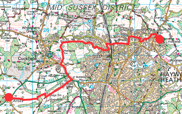
1. WAYMARKER 1 is on the corner of The Wilderness and Dukes Road. Leave the car park and walk toward All Saints Church, go through the churchyard to reach the High Street and cross over the road to the start of the walk. Directly opposite The Tiger, take the left-hand path which is marked with a public footpath sign. Follow it for a short way, it bears to the left and goes down a narrow twitten between two fences.
2. At the end of the twitten, cross Hickmans Lane and head across the recreation ground toward the corner of the hedge opposite. There is a gap in the hedge just to the right marked with public footpath sign that takes you onto Pickers Green. Follow the pavement straight on, then turn left down another twitten which bends to the right and continue to the road opposite The Witch Inn.
3.Turn right and walk up the road until you see a bus stop on the left-hand side, cross the road and walk down another narrow twitten until you reach By Sunte. Bear left and continue, past Savill Road on the right and Fieldway on the left, when you reach end of the road cross over and turn left up Portsmouth Lane, passing Birchen Lane on the right
4. Just before the mini roundabout, turn right down another narrow twitten, with lots of tree roots under foot, which leads to Sunte House on your right-hand side. Follow the footpath and continue straight on (ignore the tarmac drive to your right which leads to Birchen Wood). Cross the bridge over the London to Brighton railway line and continue on to Old Wickham Lane
5. At the end of the lane use the island to cross Balcombe Road and then turn left, keep to the pavement, cross over Barnmead, and walk on until you see The Barn and a right turn with a public footpath sign. Go through the wooden gate and walk on until you reach the green opposite, head straight across to reach another narrow twitten.
6. At the end of the twitten you will see the Harland Primary School entrance opposite, go up the drive and follow the path to the right and then left beside the fence until you reach three bridges over a number of small streams. The path goes off to the right along a makeshift wooden boardwalk. At the end of the sports field keep following the fence on your left, the path bears to the right through some woods.
7.After a few hundred yards you will come across two fallen trees near to the path and some houses on your left, follow the path toward the houses to Campbell Mead. Walk straight on, past a drainage pond and small play area to your left and follow the pavement as it curves to the right, then up a couple of steps. On your left you will see a public footpath which leads you over a little bridge and into the woods.
8. Follow the path uphill, past Gravelye House on your left and then walk straight on until you reach a stile. Cross the stile and take the footpath to the left and immediately turn right an open field. Go through some trees and you will reach a footpath sign, take the left turn and walk through some wild scrubland with brambles and possibly some grazing horses. You should have a good view of the spire. This is an attractive private road and public bridleway. Follow the lane until it turns sharply to the left.
9. At Copyhold Cottage turn right onto the public footpath which goes around the back of the house, downhill, then over a stile and then around to the left by the pond at Lodge Farmhouse and through a five- bar gate. Go straight on into a field (ignore the footpath on your right and follow the left- hand side of the field downhill).
10. Go over a stream, up some wooden steps and follow the path through a small wood. At the other side of the wood you come out onto a gravelly track. Turn left through the hedge to pick up the path, there are trees on the right and a large open field to the left. Go through the gap in the hedge into the next field and continue on until you reach a house on the right.
11.Turn left and walk down the track until you reach the A272, cross over at the roundabout at the pedestrian island, keep right and follow the pavement to Deaks Lane and Ansty Recreation Ground on the right-hand side (WAYMARKER 2)
If you prefer you can download the walk guide to your phone.
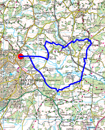
Walk 8 - Lindfield Circular
Distance: 9 miles / 14.5 km
Grading: Moderate
Location: Explorer map 135 (Ashdown Forest)
- Turn onto Brushes Lane by The Bent Arms pub on Lindfield High Street and at the junction for The Wilderness car park on your left and Dukes Road there is a public footpath by WAYMARKER 1. The path leads to a kissing gate at the entrance to the Wilderness Field, turn left to walk diagonally across the field, following the path to the far corner.
- At the five-bar gate, turn left and walk on until you reach a private road leading to a farmhouse. Turn right here and follow the tarmac road, cross over a stream and carry straight on a wide footpath which goes slightly uphill and then the footpath turns to the left by a five-bar gate.
- Go over a wooden bridge, walk on a short way and go over a second plank bridge. The footpath comes out on to a road that leads to Walstead Forge, walk straight ahead and cross straight over the busy road ahead to pick up the public footpath opposite.
- Walk slightly left across the field ahead, then cross over a private driveway and through the metal gate opposite. Walk diagonally across the field until you reach a couple of houses. Go over a stile and carry on between the houses past Keepers Cottage on your left and continue on the footpath
- The footpath crosses a field, over a stile into another field, walk diagonally across, through a kissing gate into the wood then go over a stream on a wooden bridge.
- Follow the windy path through the woods (which can be very muddy) and at the footpath junction follow the sign to the left to continue straight on. The path goes uphill through the woods until you reach a grassy clearing and a Woodland Trust bench by Costells Wood.
- You need to turn left and follow the path under the pylons overhead. Where the path divides, take the left-hand fork to stay on the Sussex Ouse Valley Way.
- The path goes between two post and rail fences and an avenue of trees and turns to the left behind an old brick house. At the end of the drive carry on down the road.
- Just before you reach Nash Lane and a little car park on the right, turn left and follow the public footpath sign into the woods down a tarmac path. When you reach the house turn right to go down a grassy
- The path goes through a wooden gate to the left of a five-bar gate along a narrow (potentially muddy) footpath between a holly hedge and a fir tree fence. Go through a tight squeeze wooden kissing gate and the path goes off to the left, diagonally across the field toward a gate in the far corner.
- Go through another kissing gate, past a little pond on the left-hand side, into a field then through a gap in the hedge and walk straight ahead across a wide open field.
- Go through a metal kissing gate and down some steps, turn left down a road and walk past Nash House with a grand Georgian The road turns to the right and just before a brick barn ahead, there is a public footpath sign directing you left behind a wooden fence (this short section can be extremely wet and muddy).
- Go through a kissing gate and head straight across the field, slightly downhill, toward the copse ahead. Go through a kissing gate on the other side of the field and then turn left through the wood (not straight ahead on the raised path).
- The path curves round to the right until you reach a stile, go past the pond with a duckhouse on the left, go through a wooden gate past a white and tiled cottage on the left, over a stile and turn right down a tarmac track which leads to Sloop Lane.
- Halfway Point / Resting Place (3 miles / 5 km): The Sloop Inn, 99 Sloop Lane, Scaynes Hill RH17 7NP country pub with beer garden, serving food and turn left along the road and walk past the Sloop Inn; there is no pavement so take care and walk on the grass verge toward the oncoming traffic. Go over a bridge, past the farmyard barns on the right, then over another bridge across river. Walk past Freshfield Mill Farm on the right and Freshmill Cottage on the left, then as the road bears to the left you will see a public footpath up a few steps on the right
- Over a stile and then turn slight left and walk straight ahead, uphill across the field toward a brick bridge over the Bluebell Railway. Cross the railway and then go straight ahead on the track ahead, when you reach the tree line turn left over a wooden plank bridge into a The path goes diagonally left slightly uphill.
- Walk around the back of a large country house with an orchard and out through a pedestrian wooden gate. Turn right along the road, past the wooden beamed Town Place and then turn left through a gate along the footpath, past a vineyard on the right.
- Go through two kissing gates and into a wooded area until you reach a track where you need to turn left and walk on, following the Sussex Diamond Way, until you reach Freshfield Lane. Cross over and turn left along the grass verge, then just past the West Sussex boundary sign you can turn right onto a public footpath which leads to a quarry. Turn right and follow the fencing around the back of the quarry, the footpath bears left into the woods, downhill with a large lake on the right.
- Over a wooden bridge and then the footpath turns to the left down a track. Go past the entry to the quarry on the left and the path continues straight ahead (ignore private track to the right). The footpath comes out on Treemans Road, go down some steps, cross over, through a gate to follow the footpath opposite.
- Over a stile and the path goes off to the right, over another stile and then diagonally left through a kissing gate. Walk on and at the corner of the post and rail fence turn right, over a stile and a little plank bridge, up some steep steps and over the Bluebell Railway line. Beware of Trains!
- Down a few steps, over a high wooden bridge and follow the path through the trees. Through a gate, over a wide concrete bridge and up through the middle of a field. Go over the stile and at the path ahead turn right.
- When you reach the wooded area turn left to follow the footpath through the trees. Carry straight on, go through a little metal gate and turn left down Plummerden Lane for a short way.
- Just before Great Plummerden Cottage turn right and follow the public footpath through the vineyard. When you reach the treeline go through a metal 5-bar gate and turn left.
- Go through a metal kissing gate and then turn left. Through another kissing gate and then turn left up the drive to Little Plummerden. The footpath goes off to the right past the house on your left and to the right of the garage.
- Go through a kissing gate, through another little gate and walk down the right hand edge of the field until you reach a little wooden bridge over a stream. Turn right and then the path turns left along the front of the Lindfield Golf Course.
- The footpath comes out onto East Mascalls Lane and you need to turn right, it is quite a fast road with no pavement so be careful and walk in single file on the right hand side so you can see oncoming traffic to follow The Highway Code. Go past East Mascalls Farm and over the River Ouse, then turn right onto The Sussex Diamond Way footpath that runs along the side of the river.
- Where the river bears right (before you reach the end of the field), the path turns left across the field toward a small bridge and a gap in the trees. Go straight ahead, slightly uphill toward some farm buildings to your right.
- Go through a gap in the fence by a 5-bar gate and follow the path straight ahead. Then turn right, following the public footpath into the Wilderness Field. Head diagonally across the field to retrace your steps back to WAYMARKER 1.
If you prefer you can download the walk guide to your phone.